Webinar: A New Dawn for Plant Records at Zoos and Aquariums

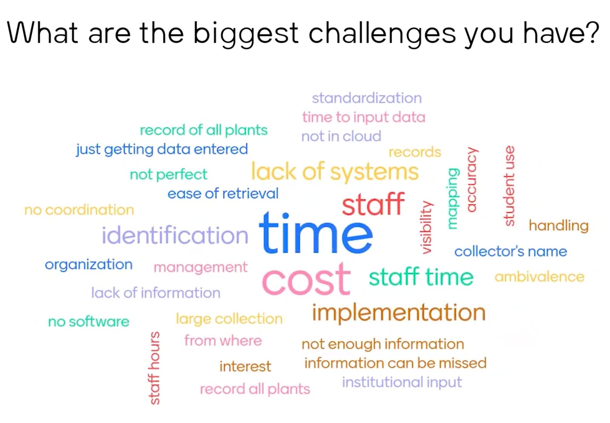
As well as being a beautiful backdrop in the zoo, plants play a vital role in creating natural enclosures, participating in educational programs, supporting animal nutrition and enrichment, and contributing to species conservation efforts. Zoos and aquariums often face challenges when it comes to botanical record-keeping, normally caused by inadequate record-keeping tools and a lack of resources.
In our recent webinar, we examined these issues and also touched on the four pillars of healthy plant records: taxonomy, inventory gap, provenance, and plant identification. With reliable data, you too can make informed decisions within your institution and give your plant collection greater potential to contribute to a broader context, locally and globally.
Getting started with plant records may seem daunting, but it doesn't have to be. With little training, you can quickly and easily build up a fully digitized, mapped, and photographed collection. Hortis is thoughtfully designed to run smoothly on mobile, tablet and PC, making record-keeping a breeze.
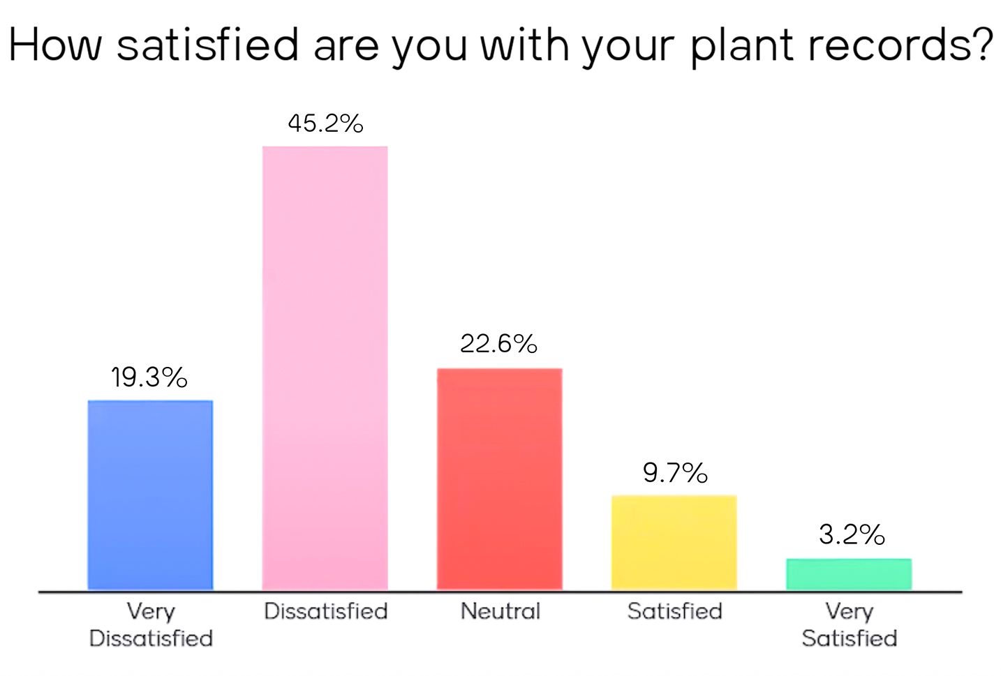
During our webinar, delegates were asked to participate in live polls, and we thank everyone for their engagement during the session.


Whether you're just starting or looking to migrate your existing plant records, we are here to assist you every step of the way and look forward to welcoming more of you on board soon.

Sign up before 30th June 2024 and take advantage of our early bird discount of 20% on the first year's Hortis subscription available to all Species360 Members.
FAQs during the session
Can I transfer my data from spreadsheets, databases, or other systems?
Yes, we help transfer your data to ensure a seamless onboarding experience. There may be a cost for data transfer, dependent on the size and complexity of your dataset. If you would like to discuss your transfer requirements, feel free to get in touch.
Is it possible to add a group of plants rather than as individuals? E.g. a large stand of willow?
Yes, plant materials can be tracked as individuals or as a group, depending on the desired level of detail you have for mapping and tracking your collection.
How precise is the mapping resolution – as good as the GPS signal of the phone?
The map coordinates themselves are very precise, offering sub-centimeter precision. However, the precision of coordinates provided by a GPS/GNSS device highly depends on the quality of the equipment and how many obstructions you might have between the device and the satellites. A consumer smartphone often performs poorly in a garden with tree canopies and buildings, reducing the signal quality. In cases like this, using buildings and other plants as reference points for your mapping is often much more efficient and can provide sufficient accuracy. If survey grade accuracy is required, you can use high-precision GPS/GNSS devices that you can connect via Bluetooth or USB.
Is there an offline version, or the ability to load data offline and then update it?
Currently, an offline version or the ability to load data offline and then update it is unavailable. However, it's on the roadmap for development in 2025.
Is it necessary to enter data for all the fields for each plant? Is the IUCN Red List status already preloaded?
You can be as flexible as you need with entering data in Hortis. While some fields are mandatory, many are not, making the platform very permissive. The integration with IUCN and Plants of the World Online automatically provides Global Red List status and other factual taxonomic data when you select a scientific name.
Will there be an integration with ZIMS, such that they will communicate/share data with each other? For example to the ZIMS for Studbooks module?
There is value in the cross-over between plant and animal management, and we will have many opportunities to explore this together, including potential integrations between Hortis and ZIMS. We will look at these options over the course of our roadmap based on the feedback we get from the community.
Is there a feature to upload documents associated with a plant record, such as a biological materials agreement?
Currently, it's not possible to upload documents like a biological materials agreement to accompany a record in Hortis. However, this feature is on our short-term roadmap and should be available in the next 3 to 6 months.
Do the filters download to an Excel spreadsheet?
Yes, you can download a filtered subset of your data as a CSV (or the entire dataset). This functionality is available for Accessions, Plant Materials, or Taxa. It is always accessible, even for read-only users.
Does Hortis support individual use only, or does it offer functionality for connecting with other botanic gardens or zoos?
With our upcoming collection portal, you will be able to share their collection with other zoos and the wider community. We also have other collaborative features on our roadmap to allow institutions to collaborate more directly with each other.